The Canadian Drought Monitor is an invaluable tool for national climate resilience; however, a sparse network of northern climate stations, infrastructure challenges in Arctic conditions, and differences in drought-assessment methods limit its effectiveness. Strengthening Canada’s drought resilience requires better monitoring and more responsive government use of its findings to guide financial assistance for affected producers.
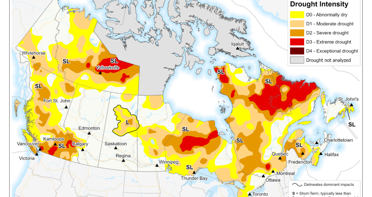
As of September 2026, 64% of Canada was classified as Abnormally Dry (D0) or in Moderate (D1) to Severe Drought (D2), including 30% of the country’s agricultural landscape.
Severe droughts can deplete soil moisture and water supplies, reduce crop yields, diminish pasture quality, and force premature livestock culling, placing significant pressure on farmers’ livelihoods. These disruptions can cause localised food shortages, threaten supply chains, and drive up grocery prices nationwide. These pressures can, in turn, cause societal distress, compound public health risks, and strain the national economy. Drought monitoring is essential to civil preparedness because it helps identify emerging shortages and direct resources before conditions become crises.
Led by Agriculture and Agri-Food Canada (AAFC) and the National Agroclimate Information Service (NAIS), the Canadian Drought Monitor (CDM) produces monthly composite maps and reports detailing the intensity and spatial extent of dry conditions across the country. Its classification system tracks dry spells from D0 (Abnormally Dry) to D4 (Exceptional Drought).
Over recent years, the CDM has expanded its toolset beyond basic climate stations to include satellite soil moisture, Normalized Difference Vegetation Index (NDVI) imagery, standardised precipitation evapotranspiration indices (SPEI), fire indices, and citizen science inputs.
Government Use of the Canadian Drought Monitor
The CDM is a key resource federal and provincial governments use to identify affected regions and guide agricultural assistance.
However, producers outside the 2023 Canada-Saskatchewan Feed Program’s CDM-guided boundaries criticised its eligibility restrictions, arguing that the smaller provincial payments available to them did not adequately reflect their drought-related losses. The 2023 Canada-Alberta Drought Livestock Assistance initiative drew similar criticism for its eligibility requirements. The Rural Municipalities of Alberta advocated for a relief approach similar to that used during the 2021 drought, when all geographic areas were eligible and individual eligibility depended on proof of drought impacts, to help ensure affected producers received support.
Eligibility was subsequently expanded. In January 2024, AAFC and its provincial partners added 23 regions in Alberta and 10 rural municipalities in Saskatchewan, extending assistance to more drought-affected producers.
NATO’s 2026 Resilience Baseline Requirements address government continuity, essential services, and communications during crises, with Requirement 4 focusing on resilient food and water supplies. As a member state, Canada’s commitment to these requirements reinforces the importance of timely disaster assistance and accessible agricultural support.
Geographic and Architectural Limitations of the Drought Monitoring Network
Gaps in Canada’s weather monitoring infrastructure limit observations in the North, weakening its ability to track changing conditions and forecast emerging risks. About 95% of Canada’s population lives south of the 55th parallel, where thousands of stations track weather metrics. Yet across the three territories and provincial regions north of this line, communities rely on a much sparser observation network to identify emerging risks.
The CDM’s monthly maps also exclude Nunavut and the Arctic Archipelago, leaving a significant gap in national drought monitoring. Lower regional population density does not reduce the need for reliable weather monitoring to protect residents and support preparedness.
Moreover, fewer than one-third of northern climate stations record at least three of five key variables (rainfall, snow depth, snowfall, temperature, and wind), a proportion that has declined over three decades. Satellite data supplement ground observations, but polar darkness and cloud cover limit optical measurements, and snow, ice, and freeze–thaw transitions require specialised methods to interpret surface conditions. Addressing this geographic imbalance requires stronger ground-observation networks, alongside satellite tools and models adapted to Arctic environments.
NATO’s Allied Command Transformation identifies extreme temperatures, deep snow, and limited daylight as challenges for Arctic operations. Stronger northern observations could support both community preparedness and Allied operations in the High North.
Do Droughts Still Happen in the Arctic?
The lack of mapped drought classifications does not mean northern communities are immune to water shortages. A study led by Dr. Elizabeth E. Webb found declining surface-water index trends in 82% of its 12-km study grid cells between 2000 and 2021. Rising temperatures are reshaping Arctic conditions and accelerating permafrost thaw, which can allow lakes and wetlands to drain even as rainfall increases. This decline in surface water can threaten drinking-water supplies for remote communities and wildlife habitat. Insufficient climate-station coverage in the Arctic limits the information available to protect northern water supplies.
NATO’s assessment report of permafrost-related security risks further underscores the importance of monitoring in the North.
Limitations in Drought Assessment Methods
The CDM combines observations, models, satellite data, and expert judgment rather than applying a single formula. Mardian et al. (2023) identify challenges in the consistency and transparency of this process.
Some regions lack sufficient local observations and expert input, so assessments draw on uneven information. Expert interpretations may also change over time, making it harder to tell whether differences between assessments reflect changing drought conditions or changes in how those conditions are judged. This raises concerns about the consistency and transparency of drought assessments.
What improvements have already been proposed?
AAFC specialists are exploring artificial intelligence and machine learning to help select indicators suited to different regions and seasons. Plans also include using 10-kilometre grid cells to address uneven information coverage. Many experts propose an explainable machine-learning framework to make assessments more consistent and identify the influence of different data inputs.
Responsible agencies must provide transparent public updates explaining which tools they use, how they have been tested, and which decisions they can reliably inform.
A Policy Proposal for Stronger Drought Resilience
First, the federal government should fund weather-resilient observation networks and soil-moisture stations north of the 55th parallel. These investments should include testing advanced technologies against physical field observations to ensure finer maps provide reliable information rather than simply increasing visual detail.
Second, Canada should strengthen domestic data capacity while also pursuing international cooperation. Space initiatives such as WildFireSat could improve observations of related hazards, while complementing drought-specific monitoring. AAFC should also evaluate whether the reported $1.65 million A.U.G. Signals initiative successfully combines satellite and field observations to provide useful agricultural information.
Third, governments should combine regional classifications with local evidence to determine relief eligibility and provide excluded producers with a clear review process. Because monthly maps cannot capture every short-term change, observations submitted through the Agroclimate Impact Reporter could help flag severe losses outside designated boundaries. These reports should prompt further assessment alongside farm records and local expertise, rather than automatically establish eligibility. Reporting should remain voluntary, not a condition of assistance.
By strengthening northern observation networks, improving assessment methods, and using local evidence to guide agricultural assistance, Canada can translate drought information into more equitable and effective action. These measures would protect communities and food supplies, support NATO’s civil preparedness and national resilience concepts, and improve environmental awareness.
Cover Photo: Canadian Drought Monitor: Conditions as of October 31, 2026” (2026), by Agriculture and Agri-Food Canada, via Government of Canada. © Government of Canada.
Disclaimer: Any views or opinions expressed in articles are solely those of the authors and do not necessarily represent the views of the NATO Association of Canada.